
Volume 8, Number 2, July 2005
A Taxonomy For Military Space Operations
- 1 School of Information Technology and Electrical Engineering, University of New South Wales, Australian Defence Force Academy, Northcott Drive, Canberra ACT 2600, Australia.
Abstract
Since dominating the high ground has always been of considerable interest to warfighters, it follows that future warfare will be dominated by the ultimate high ground—space. The most significant problem plaguing terrestrial-based communications, surveillance and weapons systems is that they are often constrained to line-of-sight, which is limited to very short ranges, particularly when the land platform is at low heights. Space-based systems offer enormous potential as platforms for repeating communications, conducting surveillance and supporting navigation over vast areas compared to terrestrial-based systems. One of the difficulties with operations in space is the general lack throughout the world’s defence forces of an agreed taxonomy. While doctrine (such as US Joint Publication JP 3-14 Joint Doctrine for Space Operations [1]) and agreed terms do exist for a number of areas of space operations, the taxonomies provided tend to be focussed on particular areas and defined around existing systems and applications. There is therefore a need for a comprehensive top-level approach to the description of the constituent elements of space operations. An important characteristic of this description is that it needs to take into account the impact of space on the providers of space services, as well as the users of these services, and the impact of space on other battlespace entities that are not direct users of space. This paper therefore proposes a taxonomy for military space operations.
Introduction
Since dominating the high ground has always been of considerable interest to warfighters, it follows that future warfare will be dominated by the ultimate high ground—space. The most significant problem plaguing terrestrial-based communications, surveillance and weapons systems is that they are often constrained to line-of-sight, which is limited to very short ranges, particularly when the land platform is at low heights. Longer ranges require communications, surveillance and weapons systems to be mounted at higher elevations—hence the interest in space.
Space-based systems offer enormous potential as platforms for repeating communications, conducting surveillance and supporting navigation over vast areas compared to terrestrial-based systems. For example, the coverage of a terrestrial military transmitter is of the order of some 15 millionths of a percent of the Earth’s surface; a transmitter from a geostationary satellite can cover approximately 42%—some 3 million times more [1].
The impact of space on future warfare is therefore very significant. First, commanders can obtain considerable advantages by mounting communications, surveillance and weapon systems on space-based platforms. Second, forces are increasingly vulnerable to the significant improvements in communications, surveillance and weapons capabilities offered to an adversary who can also operate space-based systems.
One of the difficulties with operations in space is the general lack throughout the world’s defence forces of an agreed taxonomy. A taxonomy organises a body of knowledge into an ordered hierarchical classification—of organisms, soils, music, software, and so on. A taxonomy is useful in that it provides a universal system through which all involved can have a common frame of reference. For space operations a taxonomy is essential to help identify the relationships between elements to assist in analysing functionality, allocating requirements, managing procurements, developing doctrine, conducting training, and so on.
While doctrine (such as US Joint Publication JP 3-14 Joint Doctrine for Space Operations [2]) and agreed terms do exist for a number of areas of space operations, the taxonomies provided tend to be focussed on particular areas and defined around existing systems and applications. Figure 1 illustrates the taxonomy provided by the doctrine defined within the US joint doctrine JP 3-14. Note that the taxonomy does not distinguish between the provision of effects and means, and there is no coverage of important aspects such as the protection of battlespace assets from the effects of space-based capabilities.
![JP3-14 taxonomy for space mission areas. [1]](/journals/journal-of-battlefield-technology/volume-08/issue-02/assets/8-2-3-frater/figures/figure01.gif)
A taxonomy for space operations
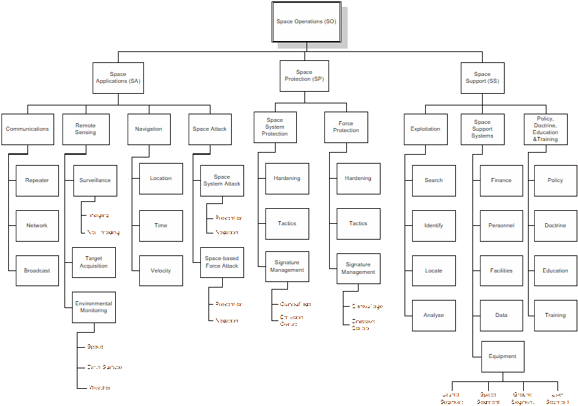
We define Space Operations (SO) as those activities involving space systems undertaken to enhance own-force warfighting capabilities and to influence adversary warfighting capabilities. This definition is deliberately broad: it encompasses the impact of space not just on those who see themselves as involved in space operations, but on the whole battlespace.
Space Operations encompass the Space Applications (SA) required to support warfighting in the modern battlespace (communications, remote sensing, navigation, and space attack) as well as Space Protection (SP) activities and the Space Support (SS) activities required to support Space Applications and Space Protection.
Figure 2 shows the relationship between the various elements of space operations, which are described in more detail in the following sections
Space applications
We define Space Applications (SA) as those applications involving space required to support warfighting in the modern battlespace, including communications, remote-sensing, navigation and attack.
Space Applications are a critical component of the support required for the complex warfighting applications of command and control (C2), network centric warfare (NCW), integrated surveillance, target acquisition and reconnaissance (ISTAR) and networked fires (including the development of a tactical engagement network).
Communications
The first use of commercial and military satellites was to provide range extension for terrestrial communications systems. One of the principal constraints for radio-frequency (RF) communication is the compromise that has to be made by designers in a design space bounded by the parameters of range, capacity, and mobility. High-capacity communications require the use of high frequencies to ensure sufficient bandwidth. High RF frequencies can only support short-range terrestrial communications, however, and above 30 MHz ranges are effectively limited to the geometric horizon. Above 1 GHz, atmospheric attenuation limits range for high-capacity links even further unless much higher transmit powers and directional, high-gain antennas are used. High-gain antennas tend to be large and, because of their narrow directional beam, require accurate orientation—all of which reduces the mobility of the terminals. A trade-off must therefore be made.
In terrestrial communications, designers optimise the capacity/range trade-off through the use of radio-relay links where, although the high frequencies used have short ranges, longer ranges are obtained by repeating through a relay station whenever the geometric horizon obstructs the path between the ends of the link. Since high RF frequencies are limited to line-of-sight ranges, the only solution to obtaining longer ranges between relay stations is to elevate the antennas at the ends of each segment of the link.
A satellite communications system is therefore basically predicated upon the ability to take this range extension to the limit through the deployment of a very high radio repeater (in geostationary Earth orbit, the repeater is 36 000 km above the Earth’s surface). While terrestrial repeaters are limited in their height by terrain and mast design, a satellite repeater (called a transponder) is principally constrained by how far away it can be placed into space and still be useful as a communications repeater.
Satellite communications applications fall into three categories:
- Repeater. The first communications use of satellites was as space-borne repeaters that were used to extend point-to-point links of terrestrial communications networks. While these uses have largely been overtaken by the much higher capacities of fibre-optical systems in commercial applications, in military applications, the requirement for mobility has seen interest in satellite-based repeater systems continue to increase.
- Network. Satellite communications networks to support mobile subscribers are provided by commercial networks such as Inmarsat, Iridium, Globalstar, New Skies, Thuraya, and ACES. The US Department of Defense is examining the development of its own military communications low-Earth orbit (LEO) constellation through the Transformational Communications MILSATCOM (TCM) programme [3], which proposes to provide up to megabits of data into terminals weighing 50 kg with small (30-cm) antennas.
- Broadcast. Broadcast systems in the commercial world focus predominantly on the broadcast of digital and analogue television signals. In military applications the US Global Broadcast System (GBS) and the equivalent Australian concept of Theatre Broadcast System (TBS) provide the opportunity to broadcast situational awareness information to terrestrial receivers with small antennas.
By 2015, it can be expected that the satellite-communications capacity available will have increased significantly. This will be brought about by increased use of higher-frequency bands (such as the Ka band). It may also be aided by new technologies, such as laser-based communications. However, achieving increases in capacity may require large antennas on a ground platform, potentially limiting the circumstances in which field forces will be able to take advantage of this increased capacity. That is, capacity to mobile satellite terminals (such as for UHF DAMA applications) is not likely to increase significantly in the near future unless access is available to systems such as TCM.
Remote sensing
Remote-sensing applications were the second major use of commercial and military satellite platforms. As well as providing a platform for long-range communications repeating and broadcast, the high elevations of space provide an ideal vantage point for surveillance, target-acquisition, and environmental-monitoring applications for military purposes.
Surveillance
Space-based platforms provide a unique location from which to acquire surveillance information that cannot be obtained from any terrestrial location. Not only do satellite platforms have a much greater field of view, but space offers relatively unfettered access to any part of the Earth’s surface with far greater ease than terrestrial sensors. There is therefore a wide range of types of surveillance satellites operating across a broad range of frequencies and applications.
While there are a number of ways to characterise sensors, in this context satellite sensors are best grouped as imaging and non-imaging sensors.
- Imaging sensors. As the name implies, the output of an imaging sensor is an image that is viewed by a human analyst or by some automatic classification technique. Imaging sensors include those operating in the visible, infrared (IR), ultraviolet (UV), thermal, and radar ranges. In the visible ranges, commercial imagery of 0.6-m resolution is available, with some considerably higher resolutions reportedly available from military satellites. Additionally, the great promise of multispectral sensors is being realised on the current generation of remote-sensing satellites, with hyperspectral sensors planned for the next generation in the next 5-10 years.
- Non-imaging sensors. Space-based, non-imaging sensors are predominantly RF sensors, mostly for signals intelligence (SIGINT) purposes. SIGINT involves the collection of adversary radio signals, called communications intelligence (COMINT), and the collection of radar signals, called electronic intelligence (ELINT). Since ground-based intercept of signals is terrain-limited, much longer intercept ranges can be achieved from elevated antennas. The long-range, broad-area coverage of space-based RF sensors plays a significant role in Electronic Warfare (EW) assets.
Sensors can also be categorised as ‘active’ or ‘passive’, depending on whether they emit radiation. For example, electro-optic sensors are normally passive and radar sensors are active.
Many countries already have active remote-sensing satellites, with some of the imagery available commercially. The availability of this imagery at resolutions of better than 1m can be expected to grow substantially in the next decade. One significant factor currently limiting deployment of many advanced systems (such as hyperspectral sensors) is cost. It can be expected that significant progress in overcoming this limitation will be made over the next ten years.
Target acquisition
On the dispersed battlefields of the future, satellite platforms provide an ideal base from which to acquire targets and provide cueing information to higher-resolution sensors. For example, space-based sensors are useful in identifying missile launch.
Environmental monitoring
Environmental monitoring provides commanders with essential information about their environment. Applications include:
- Space. Space monitoring provides information about space conditions that effect space operations.
- Earth surface. Space-based systems are ideally suited to provide wide-area monitoring of the conditions of the Earth’s surface to provide warfighters with information regarding terrain and oceanographic conditions.
- Weather. Weather has always played a crucial role in the outcomes of tactical endeavour. Warfighters are therefore well-served by accurate timely weather information. Again, the vantage point of space provides an ideal platform to monitor weather. While weather sensors are generally low-resolution, they can also be used for some limited broad-area surveillance yielding information such as vegetation patterns.
Navigation
There are three sub-divisions of the Navigation application in SA:
- Position location. Satellite-based position location provides accurate information to users on their current location (in three dimensions).
- Time. A precise time reference provides the basis of satellite navigation applications. The availability of this time reference at the receiver provides timing information with much greater accuracy than has previously been possible.
- Velocity. Velocity information may be obtained by combining position location and time measurements, or in some circumstances, by direct measurement of satellite signals.
Satellite navigation systems operate by providing a constellation of satellites (the space segment), each of which provides signals carrying precise timing references. By receiving signals from a number of these satellites, user terminals (the user segment) are able to determine their position in three dimensions and the current time.
Key issues for satellite navigation systems are:
- accuracy, which provides information on error performance achieved under optimal operating conditions;
- availability, which measures the proportion of the time that the stated accuracy is likely to be achieved; and
- integrity, which relates to the ability of a user terminal to determine whether the accuracy of a particular position measurement is acceptable, preferably without reference to any information other than that obtained from the space segment.
In the near future, it can be expected that the error in measurements provided by satellite navigation systems will be less than 1m (even from civilian systems), with high availability.
Location
A number of different platforms will be available for position location:
- Global Positioning System (GPS). Current satellite position location applications are based on the US Air Force GPS. Users can obtain increased accuracy through the use of differential GPS (DGPS), in which a correction signal is applied to a mobile GPS station based on the error observed by a fixed station at a surveyed location. GPS enables a receiver to monitor the integrity of position measurements by means of a system known as Receiver Autonomous Integrity Monitoring (RAIM). RAIM uses information obtained from satellites to construct an over-determined system of equations that makes it possible to detect when misleading information is being received from a satellite.
- Galileo. By 2008, the European Union (EU) plans to begin operation of its Global Navigation Satellite System (GNSS), known as Galileo. Unlike GPS, Galileo is controlled by civilian authorities. Galileo is anticipated to provide accuracy of better than ±1m.
- Glosnass. Glosnass is a Russian satellite-based position locating system, which provides similar capabilities to GPS.
The accuracy in position location available from a satellite navigation system has an important impact on the applications for which it is suitable. For example, an accuracy of ±100m is sufficient for enroute aircraft navigation, but not sufficient for target acquisition of an armoured vehicle, which may require accuracy of ±1m or better.
The expected availability of a satellite navigation system is also important. One feature of GPS is that it is possible not only to detect when accuracy drops below acceptable levels but also to predict many of these outages in advance.
Time
A precise clock is available as a side-effect of the position-location information provided by satellite navigation systems. By itself, this clock is useful for some applications. Systems such as GPS and Galileo that tie their clocks to Universal Time allow users to obtain an accurate time reference directly in the form that is used throughout the world.
Applications of precise time references derived from satellite navigation systems include:
- provision of an accurate time reference to all users that removes the need to manually ‘synchronise watches’;
- synchronisation of communications systems; and
- synchronisation of communications security (COMSEC) and transmission security (TRANSEC) systems, removing the need for these systems to transmit preambles that are highly vulnerable to jamming.
Factors limiting availability and integrity of time services are essentially the same as those relating to location.
Space attack
We define Space Attack as those actions, involving one or more space-based systems, taken to prevent or negate an adversary’s capabilities.
Space attack may involve:
- attack of a space-based system by another space-based system,
- attack of a space-based system by a non-space system, or
- attack of a non-space system by a space-based system.
We categorise attack of space systems as Space System Attack, and attack by space systems of non-space systems as Space-based Force Attack.
The means by which Space Attack may be carried out include techniques of Electronic Attack (as part of EW) and physical disruption or destruction, perhaps involving the use of a projectile or explosive-based weapon, or some laser or RF weapon. Where Space Attack is used to target navigation systems, it is a component of NAVWAR.
Specialist satellite payloads are required to conduct space-based disruption and destruction as part of Space Attack. Such payloads are not normally carried by commercial satellites, but rather by military satellites. Conventional payloads may be used to conduct deception as part of Space Attack.
Space Attack may include the following elements:
- Prevention involves measures undertaken to preclude a particular adversary capability, such as the use of space (through military, diplomatic, political or economic measures.) Prevention could include such actions as preventing an adversary from obtaining approval to launch a space segment or denial of a suitable location for a ground facility.
- Negation of adversary space capabilities has a number of facets:
- Deception is designed to mislead an adversary. Deception may take the form of Electronic Deception practised in EW.
- Denial involves removing an adversary’s capability, either temporarily or permanently so that they are denied the ability to utilise that capability.
- Disruption involves temporarily reducing the utility of part or all of the adversary’s capability. Disruption may include jamming as part of Electronic Attack as part of EW.
- Degradation involves permanently reducing the utility of part or all of the adversary’s capability.
- Destruction involves permanent elimination of an adversary’s capability. Destruction may include the use of neutralisation as part of Electronic Attack. Because of the requirement for specialist equipment and training, Space Attack is typically the province of specialist troops. This is analogous to the treatment of Electronic Attack in EW as a specialist activity.
Control over Space Attack can be expected to be exercised at the highest levels, in the same way that control has always been exercised over Electronic Attack in EW. The impact of Space Attack must be traded off against the scarcity of Space Attack resources, potential loss of intelligence and compromising of security.
Space system attack
We define Space System Attack as those actions taken to prevent or negate an adversary’s space capabilities. Space Attack may target one or more of the space segment, the ground-control segment or the user segment of a satellite system. Any of the three segments may be targeted for attack from space.
Examples of Space System Attack include:
- jamming of the uplink in a satellite communications system;
- jamming of the downlink in a satellite communications system;
- jamming of a satellite navigation system;
- the use of laser to dazzle a satellite remote-sensing system;
- jamming of the downlink in a satellite remote-sensing system;
- physical attack of a ground station or a ground-control station in a satellite communications system; and
- use of a laser or radio-frequency directed-energy weapon (RF DEW) to permanently damage a space system (in the space, ground-control or user segments).
Space-based force attack
We define Space-based Force Attack as those actions taken using space-based systems to prevent or negate an adversary’s non-space capabilities.
Examples of Space-based Force Attack include:
- deception of a terrestrial navigation system by a space-based system;
- jamming of a terrestrial combat radio net by a space-based jammer; and
- the use of satellite-based laser to dazzle a ground-based sensor system.
Space protection
Space Protection comprises actions taken to protect friendly capabilities, including personnel, facilities and equipment, from adversary Space Operations and friendly Space Attack operations. Space Protection consists of two activities:
- Space System Protection, which aims to protect space systems (including the space segment, ground-control segment and user segment of a satellite system) from the impact of adversary SO and friendly Space Attack; and
- Force Protection, which relates to protection of non-space assets from the impact of adversary Space Operations and friendly Space Attack.
Many of the technologies required for Space Protection are already well understood. Cost is a major factor limiting their current deployment. These technologies do not typically have any commercial application, which means that they are unlikely to be available from a commercial satellite operator.
Space Protection may involve:
- Hardening—the physical and/or electrical hardening of space systems.
- Tactics—judicious use of systems to avoid action against them.
- Signature management—the use of camouflage and emission control to prevent the detection of own-force systems and their operation.
Activities in Space Protection designed to ensure the integrity of navigation systems are a component of NAVWAR.
Unlike Space Attack and Space Exploitation, SP must be undertaken by every person and facility in the battlespace, regardless of whether or not these battlespace entities see themselves as participating in Space Operations. This is simply because all battlespace entities are vulnerable to adversary Space Attack, regardless of whether or not they are actively participating in Space Operations.
Space system protection
Space System Protection comprises actions taken to protect friendly space capabilities, including personnel, facilities and equipment, from adversary Space Operations and friendly Space Attack operations.
Space System Protection may protect one or more of the space segment, the ground-control segment or the user segment of a satellite system.
Examples of Space System Protection include:
- hardening of satellite components to protect against attack by laser and RF weapons;
- encryption of satellite telemetry to protect against stealing of the satellite;
- use of frequency spreading to protection space-based navigation system from jamming;
- planning to ensure the availability of alternate means to space systems; and
- sharing of satellite systems with other users to decrease attractiveness of attack to an adversary (such as, leasing capacity on a commercial satellite).
Force protection
Force Protection comprises actions that are undertaken to protect friendly non-space capabilities, including personnel, facilities and equipment, from adversary Space Operations and friendly Space Attack operations.
Examples of Force Protection include:
- adaptation of camouflage techniques for ground systems to take into account space-based threats;
- planning to ensure the availability of alternate means to vulnerable terrestrial systems; and
- altering the signatures of a force when surveillance assets are active to prevent accurate intelligence gathering by an adversary or potential adversary.
Space support
Space Applications and Space Protection must be supported by appropriate Space Support systems as well as good space policy, doctrine, education and training.
Space exploitation
Space Exploitation comprises actions taken to search for, identify, locate and analyse space systems. Space Exploitation is carried out at the tactical level for purposes such as immediate threat recognition, and to provide targeting information for Space Attack. Space Exploitation is carried out at the strategic level to provide long-term intelligence about the capabilities of systems owned or used by potential adversaries.
Space Exploitation can be sub-divided into:
- search,
- identification,
- location, and
- analysis.
Space Exploitation may target one or more of the space, ground-control, or user segments of a satellite system.
- In the space segment, Space Exploitation provides information about the locations of satellites, their capabilities and the data transmitted by them.
- In the ground segment, Space Exploitation provides information about the locations of ground-control stations, their capabilities, the data transmitted by them and the capabilities of the satellite system as a whole.
- In the user segment, Space Exploitation provides information about the locations of user ground stations, their capabilities and the data transmitted by them.
Space Exploitation employs a range of passive and active sensors. Passive sensors include RF electronic support (ES) systems and imaging sensors such as IR and electro-optical (EO) imaging systems. Active systems include a variety of types of radar, including synthetic aperture radar (SAR). These sensors may operate from space-based, air, ground or sea platforms.
Because of the requirement for specialist equipment and training, Space Exploitation is typically the province of specialist troops. This is analogous to the treatment of EW Support as a specialist activity.
Space support systems
Space systems comprise much more than the satellites and their payloads. Particular attention must be paid to finance, personnel, facilities, data, and the associated equipment in the launch, space, ground and user segments:
- Finance. Space systems are expensive regardless of whether the capabilities are owned or leased.
- Personnel. As in any field of military endeavour, people are the most critical resource. To maintain any level of capability requires a sufficient pool of well-trained people supported by good human-resource management systems. Additionally, personnel at the tactical, operational and strategic levels require a general awareness of Space Operations issues.
- Facilities. Space systems require a range of facilities from offices to support staff to those required to house data and equipment.
- Data. Space systems also require a large range and quantity of data, including information relating to platform and equipment capabilities, user requirements, management and exploitation, and relevant adversary capabilities.
- Equipment. Space systems comprise a number of segments:
- Launch segment. The launch segment provides the means by which the space platform is launched into space.
- Space segment. The space segment comprises the satellite platform (often called the bus) and the payload (transponders, sensors and so on).
- Ground segment. The ground segment (also called the ground-control segment) consists of those elements required to control the overall operation of the space system, including the launch, space and user segments.
- User segment. The user segment comprises the user equipment (mostly terrestrial-based) that exploits the capability offered by the space segment. The user segment is therefore mostly user terminals with a wide range of capabilities, from simple receive-only terminals to more-sophisticated terminals allowing interaction with the platform.
Policy, doctrine, education and training
Space systems must be supported by good space policy, doctrine, education and training:
- Policy. Space policy provides the framework within which space systems are planned, acquired and operated.
- Doctrine. Space Operations will have a major impact on future warfare. Warfighting doctrine must consider the relevant issues associated with the impact of space warfare. In addition doctrine specific to space operations is required to ensure the adequate consideration of the issues associated with all aspects of Space Operations.
- Education and Training. In addition to strong doctrine, education and training programmes are required to ensure that an understanding of space issues is inculcated across the battlespace, at the tactical, operational and strategic levels.
Conclusion
Space operations have the potential to have an enormous impact on future military endeavours. This paper has proposed a broad taxonomy within which space operations can be considered and which can serve as a start point for the development of doctrine associated with the various elements of space operations.
References
[1] M.J. Ryan, Principles of Satellite Communications, Argos Press, Canberra, 2004.
[2] US JP 3-14 Joint Doctrine for Space Operations, US Department of Defense, August 2002.
[3] “Networking Moves Into the High Frontier”, Signal, April 2004, p. 59–62.