
Volume 6, Number 3, November 2003
Operational Aspects of Imaging Radar Systems in Maritime Reconnaissance Aircraft
- 1 Defence Technology Agency (DTA), Naval Base, Private Bag 32901, Devonport, Auckland, New Zealand.
Abstract
The interception of a surface vessel is an important function of a nation’s maritime military capability. Here we explore a scenario where a reconnaissance aircraft is used to cue a surface naval vessel to intercept a suspect vessel amongst a number of non-target vessels. The effect of upgrading the aircraft’s radar suite from non-imaging to imaging-capable is examined. Substantial savings of up to 11% in flight time and 16% in fuel consumption are found when the latter is used. Greater savings are generally found for larger (in radar cross-section) target vessels and these savings increase with the number of non-targets vessels present—12, 24 and 36 vessels are tested here. The situation is found to worsen significantly if sufficient standby aircraft are not available to maintain target surveillance during refuelling times. Therefore, acquisition of expensive technology must be accompanied by appropriate platform maintenance and operating policies.
Introduction
When considering the future sensor requirements for a nation’s military reconnaissance aircraft it is important to provide a scientific background to decisions that are made.
Here we present a study of a particular scenario that an air force may be expected to deal with—the detection of a target vessel in a large oceanic area with a number of non-target vessels complicating the search. We are interested in the effect the replacement of a non-imaging radar system with an imaging capable (SAR/ ISAR) system would have on the cost and efficiency of search operations.
The MANA model
The MANA model [1,2] is used for this study. MANA is a cellular automata model where each automaton is endowed with a particular character that shapes its interactions with its neighbours. Each decision made by the model is based upon a set of pseudo-random numbers weighted according to the characters of the participating entities. In the current study these are a maritime patrol aircraft and a number of surface vessels. Following the approach, a large number of model runs are computed in order to obtain representative values for parameters of interest.
Interception scenario
Here we use a scenario as a hypothetical example.
authorities have been alerted to the imminent arrival of a vessel of interest (target vessel) within 500 nautical miles (nmi) of the country. Broadly speaking, this target could represent any number of vessels of a high level of political importance passing near to . For example, it could contain terrorists, a significant drug haul, a large group of illegal immigrants, or nuclear waste. While each of these variations would play out slightly differently, the basic capabilities required to intercept each are the same. For the sake of this study, we assume that the target vessel is believed to be intending to either enter or pass near enough to cause some significant threat, but it is not known where or when the vessel intends to do so.
Figure 1 shows a screen shot of the scenario. Clearly, a single naval vessel is unable to position itself at a given entry point without an indication of the direction the target vessel is heading. Intelligence is therefore required from a reconnaissance asset.
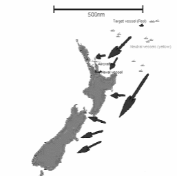
In a typical run of the model, the search aircraft leaves and attempts to find the target vessel. Once it has recognised the target it guides the naval vessel to intercept it. Note that this is not supposed to represent that the naval ship “boards” the target at that point; rather, it positions itself to shadow the vessel so that it may take action if necessary. The number of non-target vessels is varied from 12 to 36 to study the effect of the background population upon the ability to detect the target.
It is assumed that the aircraft and ship must both detect and recognise possible targets. So, in the case of the aircraft, it may detect the presence of a vessel on its radar, then fly towards it. A vessel is only recognised as the target when the patrol aircraft is close enough to do so.
It is assumed that a standby aircraft will be available to take over on-station when the patrol aircraft needs to return for refuelling. A variation is considered where this is not the case to illustrate the relative importance of this compared with the sensor configuration.
Model implementation
The scenario was implemented in MANA Version 2.0. The model used a 200×200 grid, with each cell representing an area of 5 nmi × 5 nmi. Scaling the maximum speed of the aircraft with respect to the model grid led to each model time step representing 1.1 minutes of real time.
Two types of target sea-going vessel were explored in these scenarios: fishing trawlers and container ships. The key characteristics of the aircraft and the sea-going vessels are summarised in Table 1. It is assumed in each of these cases that the non-target vessels present similar, or larger, radar cross-sections to the sought-after target. Further, it is assumed that the target is visually distinguishable from these non-targets.
The reconnaissance aircraft cruises within the model at a speed of 270 knots at 9,000-ft altitude. When an imaging radar system is not available low-altitude visual inspection of each (radar) detected vessel takes place until the target is found. This inspection phase is parameterised in the model by allowing two extra minutes per radar contact for the decrease in airspeed associated with lower altitude and manoeuvre about the target. The ascent/descent cycle associated with each inspection is assumed to take 14 minutes, during which time the altitude of the aircraft changes from 9 000 to 1 000 ft, the airspeed changes from 270 knots to 200 knots and the fuel consumption changes from 4 500 to 5 200 lb/hr.
| Craft Type | Speed (knots) | Target Vessel Size | (nmi) | (nmi) |
|---|---|---|---|---|
| Aircraft (standard radar) | 270 | Patrol boat / small trawler | 60 | 10 |
| Container ship | 100 | 10 | ||
| Aircraft (imaging radar) | 270 | Patrol boat / small trawler | 60 | 60 |
| Container ship | 100 | 100 | ||
| Naval vessel | 20 | All | 20 | 10 |
| Target vessel | 10 | N/A | N/A | N/A |
| Incidental vessels | 10 | N/A | N/A | N/A |
Flight plans appropriate to the sensor range for each of the types of target vessel were formulated. These plans aimed to completely cover the area in which the vessels lie in Figure 1.
The difference made by having standby aircraft available during refuelling was also explored. Two situations are considered. In the first it is assumed that a backup airplane is available to take over on station when the reconnaissance plane needs to refuel. This is represented in the model by preventing the aircraft from entering the refuel state. In the second situation the aircraft must return to base and leave the search/vessel contact uncovered while refuelling takes place. This is represented in the model by the aircraft initially having nine hours of search time. After this time has elapsed the aircraft is triggered into a “refuel” state. During this time it is assumed to have returned home and then to have returned to the point where it left the search: 1.5 hours is allowed for the return to base, then 2 hours to refuel, and finally another 1.5 hours to return to the search area. (The provision of a fresh crew at the base is implicit.) This is represented in the model by the aircraft remaining motionless and sensor-less for five hours at its last recorded position on the search grid.
Results and discussion
In the following discussions it should be noted that an interception probability of 100% was found in all cases. A lower probability of interception would likely have been obtained if a time limit had been placed on the model runs. This probability is of course governed by the cueing of the aircraft to the correct region of ocean when the target vessel is present there.
We begin with results obtained when a standby aircraft was always available to take over during refuelling.
Effect of surface vessel density on flight time
A distinguishing feature of aircraft equipped with imaging and non-imaging radar systems is their response to a change in the number of vessels within the search area.
Variations were tried with 12, 24 and 36 incidental vessels. Additionally the effect of dispersing 12 of these vessels within an area four times larger was investigated.
Figure 2(a) shows that for fishing trawler targets there is no increase in the model time with increasing vessel number (to within ~10 minute uncertainty) when an imaging-capable radar system is used. In contrast a clear trend of increasing flight time with increasing vessel numbers is observed when a standard non-imaging system is used. Therefore the time savings obtained by upgrading to imaging-capable radar increases with vessel number: time savings of 4%, 7% and 9% are indicated for the cases of 12, 24 and 36 vessels respectively.
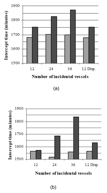
A similar graphic is shown in Figure 2(b) for the detection of container ships. On comparing this with the trawler results, it is found that the larger sensor ranges associated with container ship detection enable a faster intercept in all cases. Otherwise, the same general trends are evident. The use of SAR/ISAR is found to save 1%, 10% and 15% of flight time for the 12, 24 and 36 vessel cases respectively over that required when a non-imaging radar system is used. All of these time savings are significant apart from the 1% saving, which falls below the level of statistical uncertainty (2%).
Generally the flight times recorded for both imaging and non-imaging radars are not found to change as the 12-vessel dispersion is increased. The only change caused by this dispersion is a small increase in intercept time for container ships when non-imaging radar is used. The imaging radar results can be understood in the context that the underlying vessel density does not affect aircraft using such instruments. The lack of time increase when non-imaging radar is used to detect dispersed trawlers may result from the fact that this increased dispersion will place some of the vessels in positions where they are not detectable. Another factor is that a smaller average deviation from the flight plan may be required for contact with the dispersed trawler fleet as compared to that required from the wider area-covering flight plan followed for the container fleet. Further inquiry reveals an increase in the number of vessel contacts when the container ship dispersion is increased and a decrease in the number of contacts in the same situation for fishing trawlers. This lends support to the hypothesis that the sensor-range/flight-plan combination contrives to make some of the trawlers undetectable by the aircraft while the sensor range to container ships is sufficient to allow detection of these dispersed craft, and thus require large deviations from the flight plan to inspect them.
Figure 2 clearly shows that the deviations from the flight plan to check on each vessel at low altitude take a significant amount of the total flight time. It is evident that imaging radar allows an aircraft to traverse much denser areas of shipping when seeking a target than might otherwise have been possible with a standard radar system.
Aircraft fatigue and fuel efficiency
Figure 2 has shown that less time is spent searching for vessels when an imaging capability is added to a standard radar system. In the case of the latter some of this extra flight time is spent descending to, and ascending from, low altitude. These descent/ascent cycles increase fatigue on the aircraft while the time spent at lower altitudes increases fuel consumption and, in a maritime environment, the aircraft body corrosion. Assuming a clear distinction between the target vessel and those surrounding it, only a small amount of low altitude flight is necessary when imaging radar capability is available. This low-altitude time is considered to be sufficiently small to be ignored here.
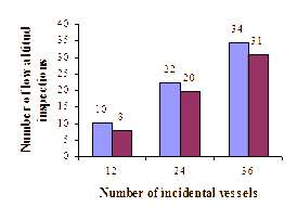
Figure 3 shows that up to 34 low altitude inspections are required in the current scenario when an imaging radar capability is not available.
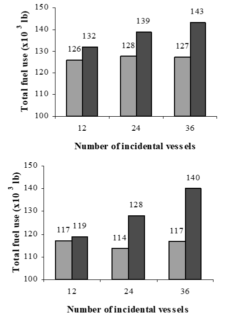
The use of imaging-capable radar systems also lowers the fuel consumption of the aircraft. This saving comes not only from the shorter intercept times (Figure 2) but also from the lack of low-altitude flying. Figure 4 shows that savings of 5%, 8%, and 11% are achieved when searching in areas with 12, 24 and 36 non-target fishing trawlers respectively. When searching for container ships in the same increasing number density, generally greater savings are achieved of: 2%, 11%, and 16% respectively. Note that the 2% fuel saving is at the level of statistical uncertainty (2%) so cannot be considered significant.
Availability of standby aircraft
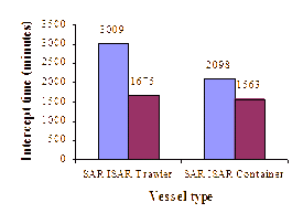
The availability of a standby aircraft is found to assume great importance in long searches. Figure 5 shows that the average time to intercept is significantly reduced when a standby aircraft is available (imaging-capable radar is assumed for all of these intercepts). When a 12-vessel density is assumed a 44% time saving is realised when searching for fishing trawlers and 26% for container ships. The larger saving for trawlers is due to the greater difficulty of detecting such vessels once they are lost during refuelling.
Conclusions
Significant savings have been estimated when an imaging-radar capability is added to existing reconnaissance aircraft assets. These savings extend over flight time, aircraft fatigue and fuel consumption. The level of savings is found to strongly depend on the number of non-target vessels in the search area. A maximum of 36 of these was considered in the current study. In areas such as the much larger vessel numbers are expected which would result in larger savings. If the aim is to have aircraft capable of patrolling in such regions then efficiencies achieved by technologies like imaging radar become increasingly important.
Savings in parameters such as intercept time will lead to some reductions in the overall operating cost of an air force. However, in a critical scenario like that presented here the national security aspects of expeditious threat interception are likely to be considered most important.
This study has been designed so that the intercept probability for the target vessel is 100% when a flight plan is chosen which completely covers the target area. A key assumption here is that the target vessel is always within this area. Imaging radar would likely offer benefits in the detection and recognition of vessels on the periphery of the search area owing to the increased ability to standoff and recognise several targets, possibly in opposing directions.
We have included a test to determine the level of flight time savings that might be achieved if a standby aircraft is always available to take over during refuelling as opposed to the case where the search area must be left unattended when returning to base. The level of flight time savings found in this case exceeded, by about an order of magnitude, the savings found when imaging radar was added. This emphasizes that while new tools may afford some welcome efficiencies it is also important that less “glamorous” activities such as aircraft service scheduling must not be neglected. It also sets a limit on the minimum number of maritime patrol aircraft a small nation’s air force needs. For example, if we consider that two aircraft are required to keep up a sustained operation like the one considered here and, at the same time, another aircraft could be in maintenance, one could be in use for training and one on foreign operations, then at least five aircraft are needed.
References
[1] M. Lauren, R. Stephen “Map-Aware Non-Uniform Automata - A Approach To Scenario Modelling”, Journal of Battlefield Technology, Vol. 5, No. 1, March 2002.
[2] M. Lauren, R. Stephen, M. Anderson “MANA 1.0 User Manual”, Technical Note, NR 1365, Defence Technology Agency, , 2001.
Dr David Galligan and Dr Michael Lauren are Operational Analysts at the Defence Technology Agency in Auckland, . David (d.galligan@dta.mil.nz) has a PhD in Radar Meteor Physics from the and Michael (m.lauren@dta.mil.nz) has a PhD in Atmospheric Physics from the .